Resource Roads in British Columbia: Environmental challenges at a landscape level
- Start Date: May 14, 2014
- End Date: May 15, 2014
- City: Nelson, BC
- Venue: Prestige Lakeside Resort
- conference proceedings now available
Conference Description
conference proceedings is available here (.pdf)
Within BC, paved and unpaved road length increased by 82% between 1988 and 2005. In 2000, there were over 420,000 road-stream crossings in BC; over the following five years, road-stream crossings increased by about 13,000 per year (BC Ministry of Environment 2007). Across the province, estimates of unpaved roads vary from 400,000 to 550,000 km (Forest Practices Board 2005).
Since then, more roads have been built by companies in the forest, oil, gas, mineral, and hydro-electric sectors. At the same time, many roads have been abandoned and have become unusable due to a lack of resources for maintenance; others have been intentionally closed or decommissioned. Thus recreational access has been constrained. The environmental effects of roads are diverse, and include impacts on aquatic and terrestrial wildlife, plants, and their habitats, as well as ecosystem and biophysical processes (including soils, water, and air).
At this conference, we’ll address road-network effects and management responses for addressing landscape-level environmental and social impacts. Topics of interest include road effects, strategic planning, tools, and administration.
We anticipate talks that summarize the positive and negative effects of road networks across large regions or landscapes. We’ll follow this with specific research findings and case studies. As well, we expect talks will address strategic road-network solutions. It’s likely we’ll have a panel to address road-related regulatory aspects.
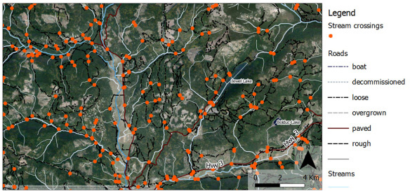
Map of stream crossings west of Grand Forks, BC.

Photo courtesy of Regional District of Kootenay-Boundary
CMI gives big THANKS to these event supporters:
Stantec, Masse Environmental Consultants, and the Columbia Basin Trust !


